(Header Image: Aerial Shot of Tysons Corner, Virginia, 2010. Source: Wikimedia Commons. Original Image Link here. No changes were made to this image from its original state.)
Up until the 1960s, the intersection of Route 123 and Route 7 in northern Fairfax County, Virginia, located roughly ten miles northwest of the heart of Washington, was a rural crossroads. The completion of the Capital Beltway spurred substantial development in this area, with a major mall, Tysons Corner Center, opening in 1968. Over subsequent decades more retail and office buildings gradually filled up the four-square-mile region of Fairfax County now known as Tysons (also known as Tysons Corner).
Such development patterns are not unique to the Washington region, of course. Virtually every large metropolitan area in the United States has developed “edge cities,” or large business and retail centers located in newer suburban areas far from traditional downtown cores. But the scale of Tysons is unmatched by any other American edge city. Today approximately 120,000 people work in Tysons, making it the country’s twelfth largest business district with more employees than the downtown areas of major cities such as Detroit and nearly as many as Denver. Tysons is home to the headquarters of five Fortune 500 companies, including Capital One and Freddie Mac, and the regional offices of many large consulting, technology and media firms. In other words, Tysons is arguably a major city in its own right.
The difference between Tysons and traditional large employment centers is that the latter are surrounded by dense commercial and residential development, including multifamily housing. Downtown Washington, for instance, is surrounded on all sides by miles of tightly packed rowhomes, mixed-use developments and apartment high-rises supported by a fairly well-developed transportation network. Detached single-family homes in the District of Columbia certainly exist, but tend to be located away from the city center and contain only twelve percent of the city’s residents..
In contrast, Tysons became what it is today only after the surrounding areas were already developed as outlying suburbs of Washington. Thus, rather than a gradual tapering off of density as you move away from Tysons, once you step outside of the boundaries of Tysons’s four square miles you immediately find yourself in neighborhoods consisting of detached single-family residential homes on large lots. The boundaries of Tysons are very evident, because, immediately beyond them, the low density can be literally seen from a satellite. The areas to the north and west of Tysons, in particular, have such low density as to appear almost rural. While similar patterns exist near many other American edge cities, Tyson’s unique scale combined with the already high cost of living in the Washington region make the consequences of these patterns especially severe in Tysons, as we will see.
Whereas the areas surrounding downtown Washington contain a plethora of housing options at varying price points, the areas surrounding Tysons contain a comparatively very small number of total homes, which tend to be very expensive. A huge share of these homes are valued at $1 million or above, making them financially out of reach for all but the top few percentiles of the country’s income distribution.
The rest of this article provides quantitative support for the notion that Tysons workers have a very small number of housing options that combine affordability and a reasonable commute.
Tysons and Surrounding Low-Density Areas
First, the interactive choropleth map below helps quantify the trends observed through satellite imagery. Using data from the 2015-2019 5-year American Community Survey (ACS) on the number of housing units and Census shapefiles on land area, we calculate the number of housing units per square mile in each census block group (A block group is the smallest geographic unit for which the Census provides information on housing and other characteristics and generally contains “between 600 and 3,000 people.”). The map below displays the number of housing units per square mile in the core counties that make up the Washington metropolitan area. We can see that the hundreds of block groups in the immediate environs of downtown Washington and Arlington generally contain over 5,000 housing units per square mile. Even in the furthest reaches of Arlington and the District of Columbia, most block groups contain over 1,500 housing units per square mile, with many pockets of much higher densities.
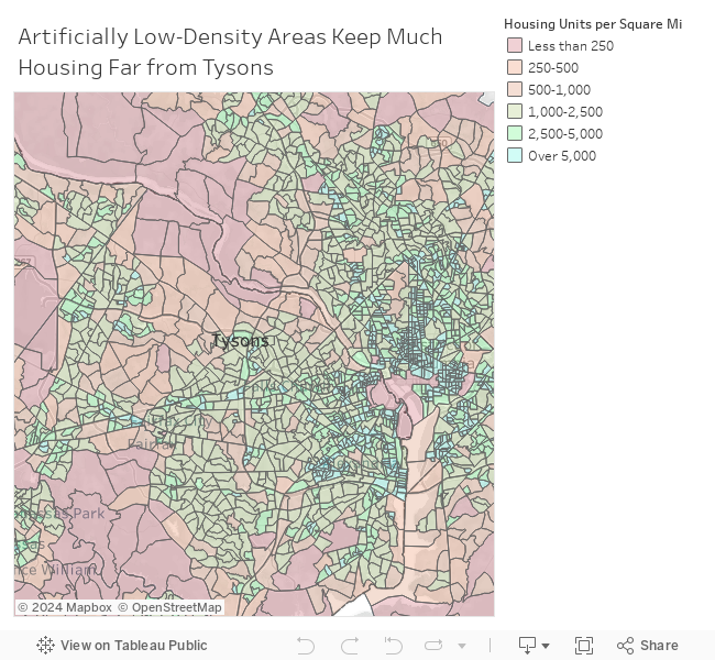
In contrast, just a few miles from Tysons, one of America’s largest employment centers, lie vast areas home to only a few hundred housing units per square mile. Tysons itself contains only four block groups with a housing density of over 5,000 housing units per square mile. Leaving the boundaries of Tysons, the low housing density in the surrounding areas becomes extremely apparent. Most block groups to the south and east have a density under 1,500 with only a few small pockets of higher density. Not only are the neighborhoods to the north and west just relatively low-density, but they are, in fact, the least dense areas within a 15-to-20 mile radius of central Washington. Clearly, a disconnect exists between the huge number of jobs located in Tysons and the very small number of houses located in the surrounding areas. Simply put, there are very few places for Tysons workers to actually live near where they work.
Not only are there a limited number of homes near Tysons, but most of those that exist are unaffordable for most Tysons workers. In this analysis, we use data from the Census Bureau on the total employment and payroll in the two ZIP codes comprising Tysons in 2017. Using the fact that wages are about 72 percent of total payroll in the Washington metropolitan area, we then estimate the average pre-tax wage of Tysons workers to be $74,879. For this analysis we consider a hypothetical household of two workers who both commute to Tysons, giving an estimated average income of $149,757. This hypothetical household is in roughly the 80th percentile of all households nationwide.
To calculate housing affordability for this couple, we again used the 2015-2019 ACS to obtain estimates of the median and first quartile home value in each census block group. Given that the average interest rate on a 30-year mortgage was 5.21% over the period 2000-2019 and the average down payment is roughly 12 percent of a home’s value, we were able to calculate the monthly cost of a 30-year mortgage (including property taxes) as a percentage of income for this household making approximately $150,000 annually. The results are displayed in the dashboard below.
The left panel shows the monthly mortgage payments for the median and first quartile home as a percentage of this couple’s pre-tax income. While housing affordability depends on many factors other than income, a commonly cited rule is that people should keep their mortgage payments under 28% of their pre-tax income. In practice, many Americans spend up to 35% of their income on a mortgage, but virtually no financial experts would consider it wise to spend much beyond this amount. With this advice in mind, almost all block groups within several miles to the north, east and west of Tysons are completely unaffordable, even when looking at the first quartile rather than the median home value. Only the areas to the south appear to have a large number of relatively affordable homes for this couple.
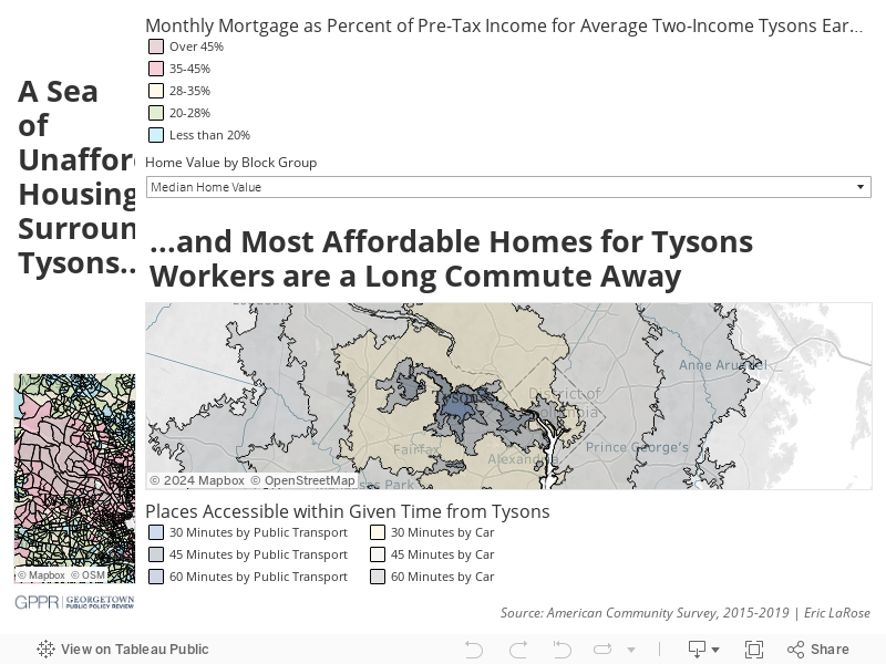
The right panel of the above dashboard makes apparent that the large areas of affordability, well to the north, west or south, involve difficult commutes. By public transport, almost none of these areas are reachable within 60 minutes. Even by car, most of these block groups are more than a 30 minute drive away. Importantly, these commute times were calculated in February 2021 using the Traveltime Platform API, which only provides travel time estimates using current traffic conditions. Thus, these travel times reflect “good” traffic rather than a typical pre- (and likely post-) pandemic rush hour commute. The Washington region consistently has among the nation’s worst rush hour commutes, meaning what appears to be a 30 minute commute in the above figure may likely be, say, 60 minutes on a Monday morning in 2019.
Unsurprisingly, the lack of housing density and the exorbitant housing prices in the areas surrounding Tysons go hand in hand. Basic economic theory, and a large volume of academic literature, suggests that a restricted supply of housing, as indicated by a low number of housing units, drives up the cost of such housing. Strikingly, the housing-scarce regions near Tysons are created and maintained by zoning regulations and other artificial restrictions, rather than geographic barriers such as steep mountain ranges. A massive share of areas near Tysons are zoned to only allow for the construction of detached single-family homes, with many containing large minimum lot sizes and other regulations that explicitly enforce low housing density. Attempts to ease zoning regulations and allow for the construction of denser, multifamily housing in these communities are met with fierce resistance from wealthy and often politically-connected homeowners.
To its credit, over the past decade Fairfax County has set out to radically transform Tysons from a massive auto-centric office park to a true transit-oriented city. The DC Metro rail system opened four new stations in Tysons, and many new residential developments have been constructed near them. By 2050 Fairfax County envisions Tysons as “a walkable, green urban center…home to up to 100,000 residents and 200,000 jobs.” But these large-scale plans confine their ambitions to the four square miles within Tysons, with no attempt to increase density in surrounding communities. Providing a large number of affordable housing options within a reasonable commute to Tysons for couples like the one we considered here will likely require that the land-use patterns of nearby towns like Vienna, McLean and Great Falls drastically change.